Bob and I were looking for the Kelstern parish church where in 1716 my 5x great grandfather Joseph PORTAS was baptized. He was more than likely born in neighboring hamlet of Lambcroft, but evidently this was the closest church which served a couple neighboring villages or hamlets. I wrote about finding his baptism entry in October 2012.
 |
St. Faith's parish church according to Richard Croft is "In an idyllic wolds setting, St. Faith's has a Perpendicular tower, and Early English font and some good windows by Sir. Ninian Comper, all lovingly cared for." [Image: © Copyright Richard Croft and licensed for reuse under this Creative Commons Licence]
|
SO WHERE IS THIS CHURCH?
Well, we knew it is on a narrow road little a couple miles north of A631 somewhere between Ludford and South Elkington in the middle of the Lincolnshire Wolds. I had my map out and we got to the Kelstern Hall gate, but couldn't see any church. We saw a few houses, but no church.
 |
Kelstern is in the middle of the above map. Ludford, Lincolnshire is about 5 miles west on A631. South Elkington about 5 miles to the east along A631. To show you here the words would be so small you couldn't make them out. [Screen shot from Classic Google Maps.]

In the above screen shot starting in lower left corner, we drove past the first house -- Kelstern Hall and proceeded on but couldn't find a road or a church. We could see a few houses, but no town. We turned around and called Cousin Margaret; she'd know. She was laughing as I explained where we were. She knew exactly how we were to get to the church. [Image above is a screen shot from Classic Google Maps.]

Evidently we hadn't gone far enough; we couldn't see the road through a hedge. We came down the road on the right and made a quick right turn and then another to be on the lane which goes between the houses we saw from the upper road. The red car on the left is pointed to the lower road which will take us to the church. According to a comment on the Rod Collin's blog post (see bottom of this posting) this triangle was the "site of a gibbet. Also that the bodies of those executed were buried under what is now regarded as the village green...a triangle of grass in the middle of three roads." [Image above is a screen shot from Classic Google Maps.]
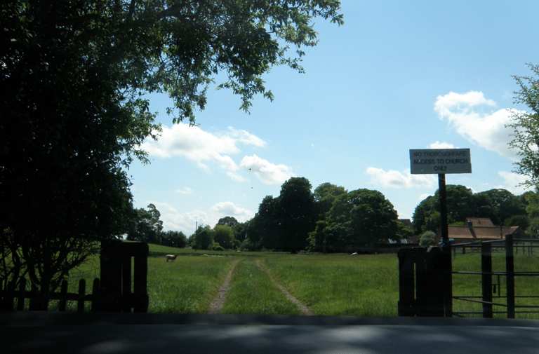
Coming to the end of the road which SURPRIZE! lead us into a pasture, we are stopped by a sign claiming "NO THOROUGHFARE ACCESS TO CHURCH ONLY" -- so should we venture forward or not? Of course! Why did we come all this way any how? [Image is by me.]

There were sheep where we would drive. Hoping they would move, we slowly drove through following the road past the first clump of trees. On our right was Kelstern Hall a little beyond the trees. The sheep did move, but were a little perturbed we disturbed their nap time and told us about it -- BA! BA! BA!. [Image is by me.]

Anyway we turned to our left and drove slowly up the hill to where we got a glimpse of the church through the grove of trees and bushes. There was a white rail fence surrounding the churchyard. We parked under the trees in a spot where there weren't any sheep and immediately a swarm of flies attached themselves to the car. Since he could get in and out of the car faster than I can... I sent Bob with my camera out to get a picture of the church. Thinking maybe we could drive into the churchyard if the gate was open. No. The gate was locked. I guess the best time to come is in the winter when there aren't any flies, but then the road might be impassable. [Image is by me.]

Bob managed to only get this shot of the church through the only opening he could find before the flies attached to him. Refer back to the beginning to see a better church picture. Luckily for us when he jumped back into the car no flies followed him. [Image is by Bob.]


He headed back toward what we think is the village. The original village of Kelstern, according to Rod Collins' blog post and comments, was nearer the church, but during the medieval times the "Black Plague" virtually wiped out the town, the surviving townspeople buried the village, and moved about a mile away to what we see today. [Image is by me.]
Rod Collins has a wonderful blog called "Lincolnsire thro' History, Life, Lens & Words / A Site About Everything & Nothing!" On October 1, 2010 Rod posted about Kelstern church and village history along with a little on Kelstern Hall. It is fascinating what he wrote and if you continue down to the comments, those are equally as interesting. I encourage you to click on the blog title to go to that posting.


No comments:
Post a Comment